
Eventos
| Xov | ||
|---|---|---|
En primeiro lugar tede sempre en conta a páxina da Comisión Interuniversitaria Galega. http://ciug.gal/ Este curso dictaron unhas normas que debedes ter en conta por precaución. Link.
E este resume das datas de calendario 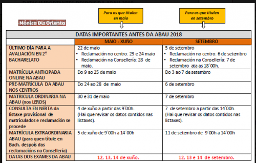  Consultade asimesmo estes documetos.
De 8:20h a 09:45h Limpeza de aula. Recollida de libros de préstamo da ESO. De 09:00h a 09:50h Representación de A noite de Fiz polo grupo de teatro para o alumnado de 2º de ESO no Salón de Actos. Salón de actos. Feira Tecnolóxica para o alumnado de 1º de ESO. Patio. De 10:00h a 12:00h Partidos no pavillón. De 12:00h a 13:00h Feira de robots: loita sumo, baile de robotiños, carreira de coches propulsados por auga e aire... Na pista exterior. 13:00h Final das clases e saída dos autobuses 13:05h Acto de fin de curso do alumnado do Ciclo. Salón de actos.
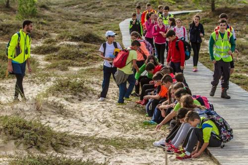
RESPÉCTANSE AS RECUPERACIÓNS QUE ESTEAN MARCADAS ESE DÍA As alumnas e os alumnos de 1º de ESO A, con Virginia, na materia de Bioloxía, investigaron os nomes dalgunhas das plantas presentes na Aguieira a partir das fotos que sacaron na Ruta da auga que fixeron a comezo de curso. Imos aprender con eles!
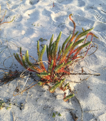
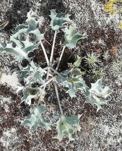
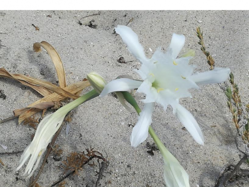
Como en todas as praias do noso entorno, a flora das dunas deste areal presenta as seguintes características:
Euphorbia paralias ou tártago de mar Planta de 30 a 60 cm, ríxida, de cor verde azulada, con follas ecuaniformes na base; follas grosas, carnosas e ovadas, de 5 a 20 mm. Dan un froito finamente granuloso.
Eryngium maritimum ou cardo de ribeira É unha planta perenne que pertece á familia das apiáceas. É nativa das rexións costeiras de Europa , cultivada frecuentemente en xardíns polas súas flores azul metálico. Son moi comúns nas dunas das praias galegas.
Pancratium maritimum ou cebola das gaivotas É un xénero de plantas herbáceas, perennes e bulbosas, nativas e pertencentes á familia das amarilidáceas.
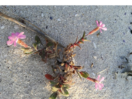
Silene gallica ou carmentilla, carmenlitilla Posúe uns talos de entre 8 e 60 cm, ergueitos e ramificados, viscosos na parte superior. As súa follas son mucronadas, miden de 2,5 a 5 cm, sésiles e lanceoladas. As flores, en inflorescencia racemosa. O cáliz pode medir entre 7 ou 11 mm, cilíndrico e contraído na parte superior. O froito en forma de cápsula ovoide, iguala o cáliz. Dáse en solos areosos, entre febreiro e outubro. En canto á distribución, está presente en case todas as rexións do mundo.
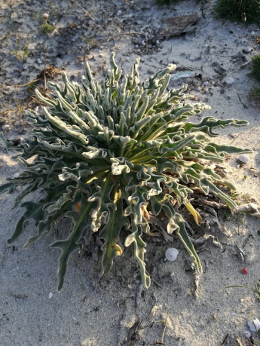
Otanthus maritumus ou algodonosa É unha planta rizomatosa (de talo subterráneo con varias xemas que crecen de forma horizontal), con talos leñosos que alcanzan un tamaño de 20 a 50 cm de altura na base. Con numerosas follas alternas, sésiles (sen pedúnculo, pecíolo ou outra forma de soporte) e ramificados na parte superior. Herba perenne densamente lanosa. Dá un froito en aquenio duns 4 mm, xeralmente comprimidos. Dáse en areais marítimos de xuño a setembro, no sur e no leste de Europa. Tomada en infusións, emprégase contra a gota.
Matthiola sinuata ou alelí marítimo É unha planta de folla perenne, cun talo de ata 40 cm. Ten flores en acio lacio (que cae liso). Folla perenne. De froito en silicua erecta. Dáse en areais e rochedos marítimos de maio a xullo. Podemos atopalo no oeste e no sur de Europa.
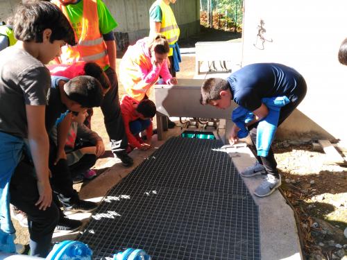
Na materia de Bioloxía, as alumnas e os alumnos de 1º de ESO B, investigaron sobre a EDAR que puideron coñecer na Ruta da Auga e queren compartilo con nós.
A auga residual é aquela que procede das nosas casas, despois de usala e consumila. O seu retorno ao medio debe realizarse coas mellores condicións, por iso, ten que ser tratada nas EDAR.
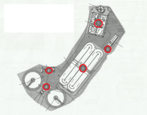
O funcionamento básico dunha EDAR implica unha serie de tratamentos que van en serie: 1.-Filtración, para quitar os fragmentos máis grandes (follas, paus, plásticos,…). 2.-Separación da area, que queda precipitada no fondo, e da graxa, que queda en suspensión 3.-Eliminación da materia orgánica mediante microorganismos, que se alimentan dela. 4.-Desinfección da auga mediante lámpadas de luz ultravioleta, a cal elimina os microorganismos que poidan causar enfermedades ao inxerilos.
Despois de realizar todos estos tratamentos, a auga xa está lista para volver ao medio. Esta auga non é potable, é dicir, non a podemos consumir. De todos os xeitos, ao non ter contaminantes nen físicos, químicos ou biolóxicos, pode resultar útil reutilizándoa para regar antes de vertela ao río ou ao mar.
A eficacia dunha EDAR depende do concello onde esté situada, pero de todos os xeitos, cada un de nos, pode poñer o seu graniño de área para contribuír ao seu mellor funcionamento.
Que podemos facer?
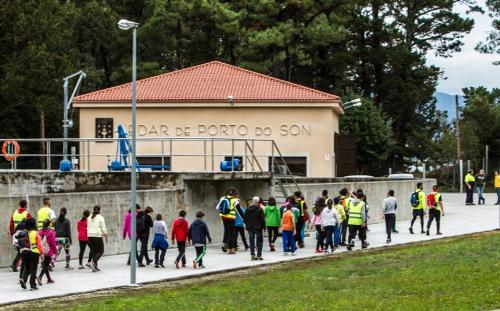
Este é o esquema da EDAR de Porto do Son que puidemos coñecer na Ruta da Auga: 1.Pretratamento 2.Desareador e desengraxador 3.Reactor biolóxico 5.Decantación secundaria 6.Desinfección por raios UV
We will start our walk from the car park outside the school and we go to the “Faro de Caveiro” which is our next stop. You go from the school to the main road AG550 and then you take the first road on the left, it is the Noal road and it is just before the Petrol Station. Then you walk towards the beach but you must take the first turning on the right and then walk along a path until you get to another road. After that you turn left and you go straight ahead and up forwards the lighthouse or Faro de Caveiro.
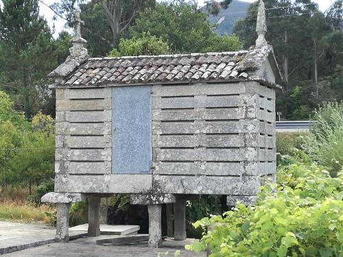
Cans is a small village of 58 inhabitants situated in the town of Porto do Son. The distance from the Aguieira beach is 850 meters and it takes about 11 minutes on foot. Here there are interesting monuments: There are the typical “Hórreos” which are stone barns where farmers store the corn they pick up from the fields.They are characteristic because they aren’t on the floor.
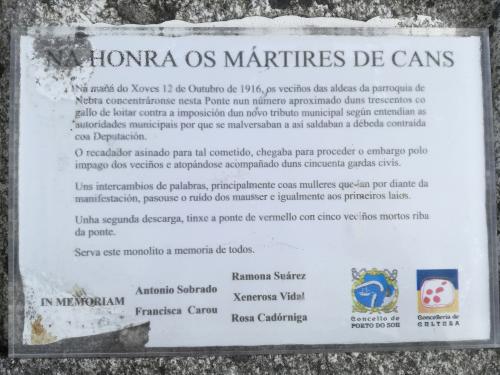
There is a “Martyrs plate”:This plate is a tribute to the martyrs of Cans who died in Nebra. Five farmers were shot by Police Agents in the Bridge of Cans , in the the parrish of Nebra on the 12th of October in the year 1906.
“The typical Washing Place”
This is a place where women wash their clothes.
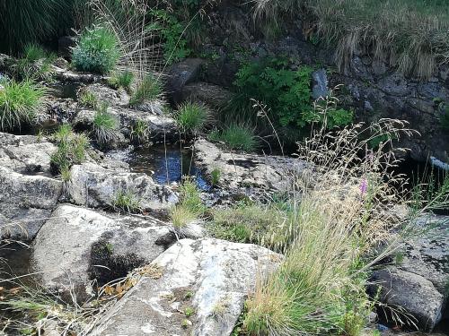
The River Cans
This is the largest river in the town. It is a quiet river which flows into the Aguieira beach a few metres after the intersection with the River Quintáns.
The Wind Mills They are places usually next to a river used to grind the corn using the energy from the wind or water.
In Cans farmers mill the corn that they later store in the barns of Cans.
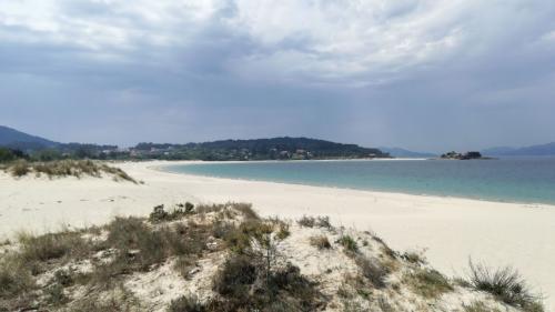
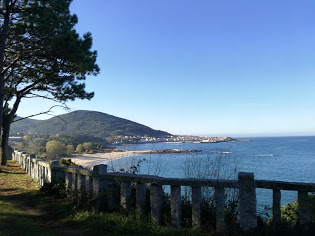
We walk during approximately 2 km until we get to the beach. It is a beach of soft, white sand with 1700 metres long and 30 metres wide when the tide is low. It has got four car parks, rubbish bins, public toilets and some beach bars. In this area there is also a school of surf, in case you want to practise this sport. In the distance you can see a small island with an old salt factory which is linked to the beach by a bridge. Near the island is a pier but of private access. The river Cans divides the beach in two parts.
After leaving the beach we get to the last stop which is the village of Cans in Nebra.
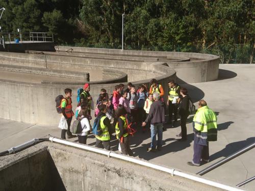
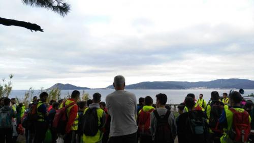
The EDAR is 500 m away from Loreto´s Picnic Area. It is a short walk of about 6 minutes with no difficulties. You can see lots of trees, birds, insects and even reptiles along the way. In this place the water is renewed. The process takes 30 minutes. A guide can explain how the dirty water gets to the plant and the process it goes through until it returns to the rivers and seas. It supplies water to the town of Porto do Son and the nearby villages. The extension of this water treatment plant is approximately 788 metres.
After leaving the EDAR we go on walking until we get to the beach of Agueira.
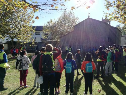
After leaving the faro you arrive at a small church next to the main road. The distance from the lighthouse is 1.1 km. It is an easy walk. This stop is Loreto´s Chapel. The church divide two parishes. The parish of San Vicente de Noal and the parish of Santa María de Nebra. They celebrate a famous “fiesta” here on the 9th of September. In the past the “fiesta of Loreto” used to be celebrated in this chapel. Nowadays a lot of people come to the celebration so the mass is in The “Picnic Area” or “Campo do Loreto”.
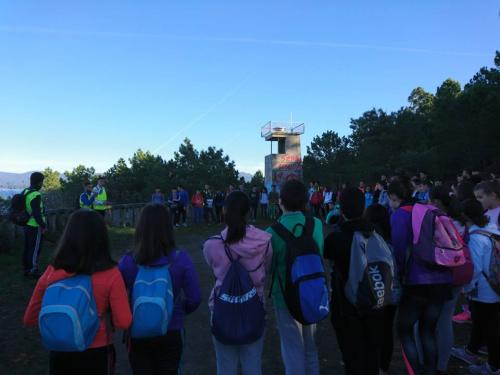
The lighthouse is grey because it is made of cement. It is 3 metres high, there is a stone banister around it. When you get to the lighthouse you can have a look, the views are amazing. Landscape interest From this point you can see: in front of you Monte Louro and the Ría of Muros and Noia. On the left is the town of Porto do Son and the beach of Caveiro and on the right Aguieira beach. The views make this place a tourist attraction. Each year hundreds of people come here. Access: It is an easy walk. Vegetation: There are a lot of trees in the area, mainly pines. The path is rocky so you must be careful. Views: You can see the town of Muros on the other part of the estuary, Monte Louro and other villages.
The lighthouse is grey because it is made of cement.It is 3 metres high, there is a stone banister around it. When you get to the lighthouse you can have a look, the views are amazing.
Landscape interest
From this point you can see: in front of you Monte Louro and the Ría of Muros and Noia. On the left is the town of Porto do Son and the beach of Caveiro and on the right Aguieira beach. The views make this place a tourist attraction. Each year hundreds of people come here.
Access: It is an easy walk.
Vegetation: There are a lot of trees in the area, mainly pines. The path is rocky so you must be careful.
Views: ou can see the town of Muros on the other part of the estuary, Monte Louro and other villages.
| ||